Going around Mono Lake
I've been curious about doing that for a few years. Most of our trips to Mono Lake were short stops on the way between Mammoth Lakes and Lake Tahoe. We've explored some of the dirt roads around Mono Lake about ten years ago in a 4WD Ford Aerostar van, but no further than Navy Beach point.
This time, I had a full day and the Disco for myself. The skies were clear, sun shone, it was about 50F and everything promised a beautiful trip.
We drove from Mammoth Lakes; at first, I tried to leave the U.S.395 on North Portal Road. It was a dirt road, this time - covered with about 4 to 8 inches of snow on iced-over ground. Somehow, busy with keeping the Disco from fishtailing, I missed the only possible turn-off that could have led North towards the lake. We've ended up back to 395 after going around a hill.
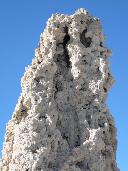
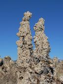
We've turned off U.S.395 to U.S.120 (closed for winter about 5 miles from 395), and then took the paved Test Station Road towards the South Tufa Beach. We've toured the beach with its amazing mineral sculptures (some of which looked as if they were the works of Auguste Rodin), and went East on the dirt two-track labelled 1N54.
At the entrance to the road, a sign read "4x4 only, soft sand ahead" - that was promising.
The road changed from a decent washboard to snow-covered washboard, snow getting deep at times enough to have to use low range to plow through. A couple of miles further, promised soft sand appeared - although nowhere deep or soft enough to cause any concerns (but hardly passable withouth four-wheel drive - with some hillclimbs and undulating between the bushes). A new treat appeared - whoop-de-doos - that were getting progressively deeper and steeper. My dog gave up his position at the shelf in the cargo compartment, and moved to the rear seat.
Our trip on the dirt road started at a very optimistic 25-mph pace - which has now reduced to about 5-10. I started wondering about how much would it take to get around the lake - any time we've stopped to take another look at the lake and the (rather useless) map, it didn't look like we were making any significant progress.
Somehow, the scenery was changing. The low sagebrush thinned out, and low cedar trees started showing up here and there. Despite no elevation change, snow almost completely disappeared. The road surface turned from compacted sand to rather hard ground, with occasional deep puddles, some frozen over.
Judging by the relative position of the town of Lee Vining and the island in the lake, it seemed like we were approaching the Eastern side of the lake.
We've driven by some 10-20 ft high sand dunes; the ground became typical for the desert floor experiencing occasional flash floods - very uneven, with erosion creating the whoop-de-doos that continued for almost two miles.
That would be the dream track for a dirt biker - and far from it in a stiffly-sprung, and heavily-loaded Land Rover.
In some places, the road crossed the wet salt flats, the tires leaving their tracks in dark-greenish smelly dirt.
Near the low, wet, and muddy North-Eastern edge of the lake, the road weaved away from the lake, and up the shallow mesa. The lake disappeared from view altogether.
A couple of miles later, we found ourselves at the edge of the paved Hwy.157. An eight-foot section of the railroad track with a small car loaded with rocks, were placed at the intersection. A memorial plaque indicated that it was a monument for Bodie and Benton narrow-gauge Railroad, built in 1881 and used until 1918.
We left the dirt, and headed West towards the U.S.395. About 25 minutes later, we drove South past the point where we left the 395 - with the total of 50 miles in the round-trip, 20 of which were on the dirt road. It was not that much of an off-road excursion - but rather a very scenic day trip, doable in a stock all-wheel-drive vehicle.
We didn't know yet that we'd come back next day, in a snowstorm, and getting out to the pavement on the hairy edge of traction. But there wasn't that much of a story.
|
|
 |
 |
 |
 |
 |
 |
 |
 |
 |
 |
 |
 |
 |
 |
 |
 |
 |
 |
 |
 |
 |
 |
 |
 |
 |
 |
 |
 |
 |
 |
 |
 |
 |
 |
 |
 |
 |
 |
|
Now, could you tell it was on a different day?
|
 |
 |
 |
 |
 |
 |
 |
 |
 |
 |
 |
 |
 |
 |
 |
 |
|